LPA outside PAR develops into tropical depression, may later become Domeng
MANILA, Philippines – A low pressure area (LPA) outside the Philippine Area of Responsibility (PAR) developed into a tropical depression on Tuesday, May 26.
As of 4 pm on Tuesday, the tropical depression was located 1,360 kilometers east of northeastern Mindanao, almost stationary or barely moving.
It has maximum sustained winds of 45 kilometers per hour and gustiness of up to 55 km/h.
The Philippine Atmospheric, Geophysical, and Astronomical Services Administration (PAGASA) said in an advisory issued at 5 pm that the tropical depression will “move erratically” in the next 24 hours as it “continues to consolidate” or further develop.
By Thursday afternoon or evening, May 28, it may enter PAR as a tropical storm and would be given the local name Domeng.
It could intensify further afterwards, possibly reaching typhoon status over the Philippine Sea on Saturday, May 30.
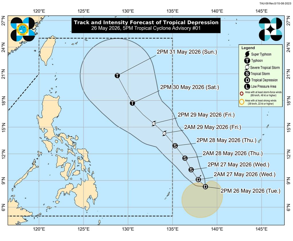
PAGASA said the incoming tropical cyclone is “less likely” to make landfall in the Philippines, but it could approach extreme Northern Luzon or the Batanes-Babuyan Islands area. If this happens, strong winds from the tropical cyclone could reach the area and Signal No. 1 might be raised.
The weather bureau added that the potential Domeng could enhance what would be the southwest monsoon or habagat by Saturday.
For now, the southwesterly windflow — the precursor of the southwest monsoon — is bringing scattered rain and thunderstorms to Palawan, the Zamboanga Peninsula, Bangsamoro Autonomous Region in Muslim Mindanao, Soccsksargen, Lanao del Norte, and Misamis Occidental on Tuesday evening.
The trough or extension of the tropical depression is affecting the rest of Mindanao, also causing scattered rain and thunderstorms.
The rest of the country will have generally fair weather, with just localized thunderstorms.
PAGASA is expected to soon declare the start of the rainy season, which typically begins in the second half of May or the first half of June. – Rappler.com


You May Also Like

Sustainable Fitch rates DBP’s sustainability bond framework as ‘good’
RBNZ July Rate Hike Risk Intensifies as Inflation Lingers, MUFG Warns

Marcos off to Japan to secure investment, trade pledges